

A broad, sunlit tract can still be a poor solar farm site if floodwater cuts off access or the grid can’t accommodate its output. In Pakistan, solar farm land requirements pakistan extend beyond acreage and sunlight: terrain, drainage, usable layout, road access, grid connection, land rights and local constraints all influence feasibility.
Land selection is a critical early decision. A site that looks suitable on a map may have engineering or development barriers on the ground. Use the same screening criteria for every parcel, and record which findings are verified, unresolved or require specialist assessment.
This guide explains how to assess candidate sites for land area, topography, flood and drainage exposure, access, grid connection and land use. It also covers the studies that can follow initial screening, so you can identify risks before they shape project design. Once a site passes that assessment, site-specific engineering can inform integrated EPC planning, including the selection and design of solar modules, inverters and storage systems.
Key Takeaways
- Assess usable land, terrain, drainage, climate and layout constraints together. Total acreage alone doesn’t establish a site’s capacity.
- Use the solar farm land requirements pakistan framework to compare candidate parcels consistently. Treat screening scores as a guide, not a substitute for engineering or legal review.
- Check land control, road access, environmental constraints and a practical grid-connection pathway early. Nearby infrastructure does not guarantee available grid capacity or interconnection approval.
- Progress from desktop review to field surveys and project-specific feasibility studies before committing to development.
- Use surveyed site conditions to guide EPC planning, including civil and electrical design, module selection, inverter configuration and storage requirements.
What Makes Land Suitable for a Solar Farm in Pakistan?
A solar farm site is more than a large parcel with strong sunshine. It must accommodate a workable array layout, provide access for construction and operations, have a credible connection pathway and be developable within physical, environmental, land-use and ownership constraints. The solar farm land requirements pakistan depend on how these factors combine at a specific location.
Preliminary land suitability means a parcel appears capable of accommodating a project after initial desktop and field screening. Confirmed project feasibility requires engineering, grid, environmental, land-rights and approval assessments. A site can look promising on a map but prove impractical once usable area, access routes, drainage, land control or the connection pathway are investigated.
Acreage alone can’t establish suitability. Irregular boundaries, existing uses, setbacks, internal roads and constrained areas may reduce the space available for solar equipment. Sector context also matters. An overview of solar power in Pakistan helps distinguish the country’s wider generation landscape from the requirements of a particular project site.
How does a solar farm site differ from agricultural solar use?
A utility-scale solar farm is designed to generate electricity for a grid connection or another defined energy offtake arrangement. Its site assessment considers array layout, electrical infrastructure, construction access and the project’s connection pathway. Solar-powered irrigation, by contrast, supplies a specific agricultural operation, such as pumping water for a farm. UNIDO’s examples from Punjab and Sindh provide context for this agricultural use, not proof that a parcel is suitable for a utility-scale project.
Scale changes the assessment. A tube-well system serves a local load. A larger generation project needs a coordinated site layout and infrastructure plan, with development and approval considerations shaped by its scope and location.
Which Pakistan-specific context should shape initial screening?
Assess each parcel on its own conditions rather than treating any province as uniformly suitable. Landform, drainage, current land use, access and nearby infrastructure can vary between districts and within the same area. Record these differences for every candidate, then compare sites against the same criteria.
Investigate land tenure, current users and community context early. Unclear rights or competing uses can affect a project even when the physical site appears workable. Identify relevant land-use, environmental and grid-connection requirements for the location and project scope. Approval pathways can depend on those specifics, and proximity to infrastructure does not prove a site can connect.
How Land Area, Terrain, and Climate Affect Solar Farm Layout in Pakistan
Required land depends on the project’s target capacity and design, not on a fixed acreage-per-megawatt rule. Module dimensions and configuration, row spacing, mounting approach, access roads, electrical equipment areas, setbacks and site constraints all shape the layout. A compact, regular parcel may allow a more efficient plan than an equally large site divided by drainage channels, existing infrastructure or unusable sections.
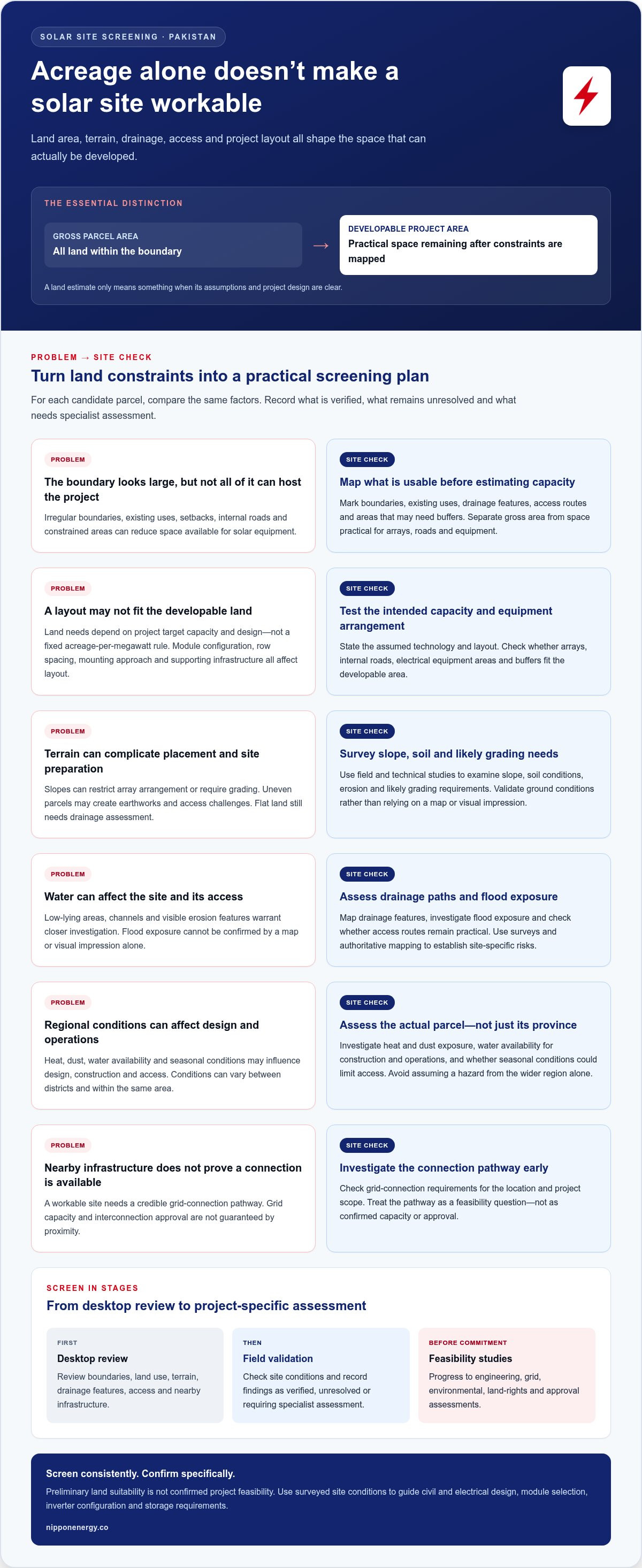
Gross parcel area and developable project area are not interchangeable. Gross area is the total land within the boundary. Developable area is what remains practical for arrays, roads, equipment and required buffers after constraints are mapped. A land estimate is meaningful only when its assumptions and project design are clear.
How much land does a solar farm need per megawatt?
There’s no universal figure that applies to every project. Land intensity varies with module and mounting design, row spacing, terrain, project configuration and supporting infrastructure. A preliminary estimate should state the assumed technology and layout, then separate gross site area from the area available for arrays, internal roads, equipment and buffers. Treat an early estimate as a screening tool, not a land commitment or final design.
Which terrain and climate conditions need site investigation?
Terrain affects both the usable layout and the work required to prepare a site. Flat land may simplify row placement, but still needs drainage assessment. Slopes can restrict array arrangement or require grading; uneven parcels may create earthworks and access challenges. Low-lying areas, channels and visible erosion features deserve closer investigation, but a map or visual impression alone can’t confirm flood exposure or ground conditions.
Field and technical studies should examine slope, drainage paths, flood exposure, soil conditions, erosion and likely grading requirements. Regional conditions also shape design. Assess heat and dust exposure, water availability for construction and operations, and whether seasonal conditions could limit access. Use surveys and authoritative mapping to establish site-specific risks rather than assuming a hazard from the province or district alone.
- Map constraints: Mark boundaries, existing uses, drainage features, access routes and areas that may need buffers.
- Test the layout: Check whether the intended capacity and equipment arrangement fit the developable area.
- Validate on site: Use field surveys and engineering studies to confirm assumptions about the ground, drainage and access.
Once a candidate parcel’s conditions are understood, integrated solar project development and EPC planning can translate those findings into a site-specific layout and engineering design.
How to Compare Pakistan Solar Farm Sites for Grid Access and Constraints
A site comparison should test more than distance to a road or substation. Evaluate land control, construction and operations access, a credible grid pathway, environmental constraints and development complexity together. These factors help distinguish an accessible parcel from one that can realistically progress toward a project.
Mapping transmission corridors and substations is useful for preliminary screening, but proximity doesn’t demonstrate available capacity, technical suitability or approved interconnection. A viable pathway requires project-specific grid studies and confirmation through the current approval process for the project’s location and configuration. Verify the roles and requirements of relevant authorities against current authoritative sources rather than assuming the same process applies across Pakistan.
How should developers assess grid connection and site access?
Which land-use and environmental constraints can change a site decision?
Review ownership records, title, encumbrances, existing land use and applicable planning controls. Screen for protected areas, watercourses, flood exposure and potential effects on nearby communities or livelihoods. Environmental assessment requirements may depend on the project and jurisdiction. Identify applicable provincial and federal processes using current official guidance before relying on a screening result.
Use the same evidence-based comparison for every candidate. The table below separates known information from unresolved questions; update its preliminary risk ratings as diligence progresses.
| Comparison factor | Evidence to collect | Open question | Preliminary risk | Next diligence action |
|---|---|---|---|---|
| Land control | Ownership records, title documents and known encumbrances | Can the required land be controlled for the project? | High if rights are unclear | Complete project-specific legal review |
| Access | Road maps, route observations and seasonal access information | Can construction and operations reach the site reliably? | Medium until field-checked | Survey routes and logistics constraints |
| Grid pathway | Mapped corridors, substations and preliminary connection options | Can studies establish a technically viable connection? | High until assessed | Advance project-specific grid studies |
| Environmental and land use | Existing-use information, authoritative mapping and site observations | Which assessments or planning controls apply? | Variable by location | Screen against current jurisdiction-specific requirements |
This framework makes solar farm land requirements pakistan easier to apply consistently: compare documented evidence, flag unknowns and assign follow-up actions before ranking parcels. A score can organize the decision, but it can’t replace engineering, environmental or legal review.
A Practical Pakistan Solar Farm Land Screening Process
Use a staged process to filter out parcels with fundamental barriers before investing in detailed studies. For each finding, record the evidence source, date reviewed and confidence level. Mark it as verified, unresolved or requiring specialist assessment. This makes assumptions visible and keeps comparisons consistent.
What should a first-pass land screening checklist include?
Start with desktop review, then build a record for each candidate parcel. Capture:
- Parcel and land control: Map boundaries, available ownership or tenure information, known encumbrances and current use.
- Physical conditions: Note terrain, visible drainage features and available mapping on flood exposure or environmental constraints.
- Access and infrastructure: Record road routes, potential construction access and preliminary grid corridors or nearby connection infrastructure.
- Development context: Identify possible community, livelihood and planning concerns, noting which findings need official or specialist review.
Compare sites against the same criteria. A simple status scale can help: advance where evidence supports further work, hold where material questions remain, and stop where a likely fatal flaw has no credible resolution path. Apply the same definitions to every parcel. Don’t let a high overall score conceal insecure land control or an unworkable grid pathway.
When should a candidate site move to detailed feasibility?
Advance a parcel only when major land, access and interconnection concerns have a credible route to investigation. A desktop map can identify a possible corridor, for example, but can’t establish technical connection feasibility. Visible road access doesn’t confirm that construction equipment can reach the site in relevant seasonal conditions.
Once a candidate clears initial screening, define follow-up work around its specific risks. This may include boundary and topographic surveys, geotechnical investigation, drainage and flood assessment, environmental and social studies, land-rights review and project-specific grid studies. Set the scope according to site conditions and applicable project requirements, not a generic checklist alone.
Keep decisions traceable: document why a site advances, what remains unresolved, who must assess it and what evidence will close each gap. Screening organizes diligence; it doesn’t replace engineering, legal review or project-specific approvals.
For context on how land screening fits into later development stages, read the solar project lifecycle guide. Nippon Energy’s solar project development and EPC connects site findings to integrated project planning.
From Suitable Land to a Solar Farm: How EPC Planning Connects the Pieces
Once a candidate site passes initial screening, survey findings become inputs to project engineering. Topography informs grading and array positioning; soil conditions inform foundation and civil design; drainage findings shape water management; and access routes guide construction logistics. Grid studies inform electrical design and the interconnection approach. At this stage, solar farm land requirements pakistan become project-specific engineering decisions, not a generic acreage checklist.
How does EPC planning respond to site-specific land conditions?
Equipment architecture should follow verified design inputs. The intended capacity, site layout, energy profile, grid conditions and operating requirements help determine whether Nippon HJT or TOPCon modules, lithium-ion battery storage and Nippon Smart AI Inverters fit the project. Assess these options as part of coordinated civil, electrical and interconnection engineering, rather than selecting equipment before the site is understood.
Nippon Energy provides solar project development and EPC, connecting these disciplines and translating site evidence into an integrated project plan. For additional context on delivery stages, see the solar EPC services guide.
What should a landowner or developer prepare for the next stage?
A structured information package helps project review begin with clearer assumptions. Organize available documents and label gaps rather than treating preliminary information as confirmed. Include:
- Parcel boundaries, ownership or land-control documents, and available land-use records.
- Boundary and topographic maps, site photographs, and notes on terrain, drainage and existing uses.
- Information on road access, nearby electrical infrastructure and any preliminary grid discussions or studies.
- A list of open issues, evidence sources, confidence levels and follow-up surveys or specialist assessments.
This record connects land screening to the next development decisions. It also makes unresolved matters visible, helping project teams sequence legal review, field surveys, engineering and applicable approvals around site-specific needs.
For landowners and developers preparing to advance a screened candidate, review Nippon Energy’s solar project development and EPC support.
Move from Site Screening to Project Design
A promising solar farm site is more than a large parcel with strong solar exposure. Its potential depends on developable area, terrain, access, land control, environmental constraints and a practical grid pathway. Applying the solar farm land requirements pakistan framework consistently helps distinguish initial suitability from confirmed project feasibility.
Screen candidate sites with documented evidence, flag unresolved risks and prioritize surveys and studies around each parcel’s conditions. Once a site advances, those findings can guide civil and electrical engineering, interconnection planning and equipment choices. Nippon Energy provides solar project development and EPC services, with HJT and TOPCon solar panels, lithium-ion storage and Smart AI Inverters among the options considered in project design.
A disciplined start can give your solar farm a stronger foundation. Review Nippon Energy’s solar project development and EPC services as you move from land assessment toward an engineered project.
Frequently Asked Questions
How many acres are needed for a 1 MW solar farm in Pakistan?
There’s no single reliable acreage figure for every 1 MW solar farm in Pakistan. The solar farm land requirements pakistan depend on the selected modules, array layout, row spacing, terrain, roads, equipment areas, setbacks and site constraints. Distinguish the parcel’s gross area from the developable area available for the project. A preliminary estimate should state its design assumptions; surveys and engineering establish the land requirement for a specific site.
Is agricultural land suitable for a solar farm in Pakistan?
Agricultural land can be considered, but suitability depends on land rights, current use, planning controls, physical conditions, environmental review and the project’s grid pathway. Existing agricultural use may also involve livelihoods or community interests that need early assessment. Solar-powered irrigation differs from a utility-scale solar farm: one supplies an agricultural load, while the other is planned as a larger generation project with its own layout and infrastructure needs.
What type of land is best for a solar farm?
The best site has secure land control, a workable layout, manageable terrain and drainage, practical construction access and a credible grid-connection pathway. Flat, open land can simplify layout, but it isn’t automatically suitable if access, land-use constraints or grid conditions create barriers. Compare candidate parcels using the same evidence-based criteria, then investigate site-specific issues through field surveys, engineering and legal review before committing to development.
How close does a solar farm need to be to a grid connection in Pakistan?
There’s no universal distance that makes a site connectable. A nearby line or substation is only a preliminary indicator, not proof of available capacity, technical suitability or approval. The practical connection route depends on project size, network conditions, connection design and the applicable process. Screen possible corridors early, then use project-specific grid studies and the current interconnection process to assess feasibility, required works and constraints.
What surveys are needed before developing a solar farm site?
Survey requirements depend on what is known about the parcel and its constraints. Initial work commonly examines boundaries and topography; further assessment may cover soil and geotechnical conditions, drainage, flood exposure, access, environmental and social factors, and grid connection. For projects requiring high-precision terrain mapping and 3D modeling, developers can explore Geospatial Surveying and Digital Twin Services to evaluate site conditions in detail. Land-rights review is also important. Use desktop information to identify questions, then define field surveys and specialist studies around site conditions and project requirements rather than relying on a generic checklist.
What approvals may be required for a solar farm in Pakistan?
Approvals are project-specific. Depending on the location, design and development structure, the process may involve land-use and land-rights matters, environmental assessment, grid interconnection and other project or electrical approvals. Requirements and responsible authorities can vary by province and project scope, so don’t assume one approval pathway applies nationwide. Identify applicable current processes using authoritative guidance, then include them in the project’s development schedule and diligence plan.
Can flood-prone or sloped land be used for a solar farm?
Potentially, but neither condition should be accepted or ruled out based on appearance alone. Slope can affect array layout, grading, foundations and access; flood exposure and drainage can influence site planning and civil design. Surveys and authoritative mapping should establish site-specific conditions, after which engineers can assess whether the risks can be addressed. If constraints make safe access, practical layout or project economics unworkable, the parcel may not be viable.
Ready to progress from site screening to project design? Explore Nippon Energy’s solar project development and EPC services.


